DISTANCE: 50-60 miles TERRAIN: Rolling hills with a few challenging climbs
Table Mountain is the second of three sections of the Wildflower Century and every April thousands of cyclists climb up and over it on their way back to Chico.
A remnant of an ancient lava flow, Table Mountain truly is table-like on top, with steep, vertical cliffs at the edges that produce some very cool looking waterfalls in the early Spring along with an abundance of wildflowers.
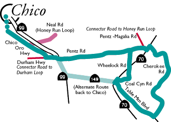
There are numerous ways to get to Table Mountain, among them by taking the Midway Bike Path to Oroville Chico Hwy, then south to Pentz Rd. and west past Butte College to Hwy 70. At Hwy 70 make a left and travel up the hill for less than a mile to Cherokee Rd. A challenging climb takes you through the old town of Cherokee and onwards to the top of Table Mountain proper. You will know when you get to the top – it is flat as a table.
The ride down the other side to the outskirts of Oroville can be dangerous – so much so that the riders in the Wildflower Century climb up from the Oroville side and go down through Cherokee. But for a single rider or small group who know the downhill is challenging, we find the Cherokee-Oroville direction more satisfying.
Once at the end of Cherokee Rd, make a right on Table Mtn. Blvd. (which has some great views of the Table Mtn cliffs) and follow it to its end. From here you have a couple of choices. You can make a left, on Hwy 70, then a quick right on Hwy. 149 to connect with Hwy. 99 back to Chico (both have a fair amount of traffic, but with a good shoulders). Or you could make a right on Hwy 70 for a mile or so and make another right onto Coal Canyon Rd. This quiet road ends up crossing Hwy 70 again in a couple of miles and changes into Wheelock Rd. which dead ends back into Durham-Pentz Rd. where a left turn takes you back to Butte College and ultimately Chico.