CHICO VELO
  • Home
  • Donate
  • OUR WORK
    • Colby Mountain Trails
    • Chico Bike Park
    • Trailworks >
      • Volunteer with Trailworks
      • Trailworks News
    • Programs >
      • Adopt-a-Path
      • Bike Month >
        • Bike to School
      • Bike Valet
  • Rides
    • Wildflower Ride & Festival
    • 2026 Gravel Grind
    • Calendar
  • Resources
    • Electric Bikes
    • Ride Safely
    • Local Information >
      • Register Your Bike
      • Local Roads and Weather
      • Local Routes
      • Decide & Ride
      • More Links
    • Bike Safety Videos
    • Advocacy >
      • Advocacy Terminology
      • Reading List
  • About
    • Staff
    • Board of Directors
    • Partners
    • Remembering Ed McLaughlin
    • Support >
      • Sponsor
      • Volunteer
      • Contact
    • Jobs
    • Newsletters
  • Store

Home » Events/Rides » Local Routes » Keefer Road Loop

Keefer Road Loop

DISTANCE: about 12 miles
TERRAIN: mostly flat
Picture
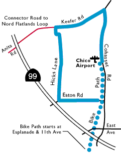
The key to this ride is getting past the traffic associated with Cohasset Road and East Ave. A couple of years ago the railroad tracks out to the Chico Airport were abandoned and a bike path put in. Getting on this bike path lets you bypass the less fun parts of this ride. You can get a Chico bike route map from most Chico bike shops or Chico City Hall.

The bike path starts at 11th Ave and the Esplanade. You'll see the bike path head north over an abandoned railroad bridge. The bike path lets you bypass all the traffic (just watch the few busy intersections you have to cross) and takes you all the way out to the airport, more-or-less paralleling Cohasset Rd.

The bikepath dumps you onto Fortress Street at the airport, which you turn left on until it ends at Ryan Ave. A right on Ryan takes you to Cohasset Rd. where you turn left. You should find this part of Cohasset Rd. much quieter and more scenic road than it is between Chico and the airport.

After grunting over a few short hills on Cohasset Rd. you will see Keefer Rd. on your left. (Going straight on Cohasset Rd. will lead to one of the tougher climbs in the area – over 2,600 ft elevation gain – up to the small hamlet of Cohasset.) A left turn on Keefer produces a short but sweet downhill to Hicks Lane and another left turn. (If you were to continue straight on Keefer, it would take you to Hwy. 99 where a left turn and a 100 yards worth of pedaling would connect you with Anita Rd. – a great road if you wanted to combine this ride with the Nord Flatlands ride – also featured on this website.)

Hicks Lane travels south through mostly unused pasturelands – look for the herd of buffalo! – adjacent to the airport runways until it comes to Eaton Rd. A left on Eaton takes you back to the bike path you came out on.
  Local Weather  |  Volunteer  |  Donate |  Contact Us | Partners | Jobs

Chico Velo is a 501.c.3 Non-Profit organization.