Chico Velo
  • Home
  • Outreach
    • Advocacy
    • Programs >
      • Adopt-a-Path
      • Trailworks >
        • Trailworks News
        • Colby Mountain Project >
          • Project Updates
          • Supporters & Donors
      • KidsPedal
      • Bike Valet
    • Resources >
      • Bike Safety Tips
      • Bike Safety Videos
      • Local Roads and Weather
      • Links
  • Rides
    • Wildflower Century
    • Ride Calendar
    • Local Routes >
      • River Road Loop
      • Nord Flatlands
      • Durham Loop
      • Keefer Road Loop
      • Honey Run Loop
      • Table Mountain Loop
      • Cohasset Climb
  • Support
    • Donate
    • Volunteer
  • About
    • Jobs
    • Staff
    • Board of Directors
    • Remembering Ed McLaughlin
    • Sponsors
    • Contact >
      • FAQ
      • Calendar Request
  • Store

Home » Events/Rides » Local Routes » Cohasset Climb

Cohasset Climb

DISTANCE: 45 miles
TERRAIN: hilly
Cohasset Climb
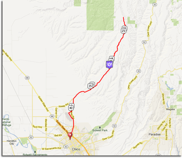
This out-and-back ride into the hills around the hamlet of Cohasset is a relatively short, but challenging ride. Options include going only as far as the store in Cohasset, cutting out about 16 miles and about 1000 feet of climbing. It's all uphill to the top, then turn around and it's all downhill back to Chico.

The bike path starts at 11th Ave and the Esplanade. You'll see the bike path head north over an abandoned railroad bridge. The bike path lets you bypass all the traffic (just watch the few busy intersections you have to cross) and takes you all the way out to the airport, more-or-less paralleling Cohasset Rd.

The bikepath dumps you onto Fortress Street at the airport, which you turn right on until it ends at Ryan Ave. A right on Ryan takes you to Cohasset Rd where you turn left. After grunting over a few short hills on Cohasset Rd you will see Keefer Rd on your left. You are going straight on Cohasset Rd all the way up to the small hamlet of Cohasset. About 1-2 miles after Keefer, the real climbing starts and keeps going until.... You can stop at the store for basic supplies just before mile 14, or keep going on Cohasset Rd up until the pavement ends at approximately mile 22.

The return is all downhill and can be quite fast. Although the road surface is very good quality and turns are reasonable, it is best to be careful – deer, wild turkeys, bears, and even mountain lions have all been spotted on this road! And since some turns are blind, you'll want to anticipate cars that might be crossing the middle yellow line.

Detailed map with elevation data here.
News  |  Calendar  |  Local Weather  |  Volunteer  |  Donate |  Contact Us

Chico Velo is a 501.c.3 Non-Profit organization.